


News - GLOBE Observer


Tree Height, Clouds, and ICESat-2: An Example of the Importance of Taking Multiple Observations at the Same Time and Same Place
Taking multiple GLOBE Program observations using the NASA GLOBE Observer – NASA GO – app’s tools (i.e. clouds, mosquito habitats, land cover, and tree height) in the same location at the same time helps students, citizen sciences, and professional researchers better understand what is happening in an environment. This ground-based data can then be compared to NASA space-based satellite and/or instrument data.
That said, there may be an issue that affects either the ground-based NASA GO data or the space-based NASA ICESat-2 satellite data.
For example, on 17 September, 2021, I wrote the blog post titled “3 Years of ICESat-2 and NASA GLOBE Observer Tree Heights”. There I demonstrated how to compare NASA GO tree height data with tree canopy height data from ICESat-2 (Ice, Cloud, and land Elevation Satellite-2) using the Open Altimetry online tool for both individual trees and groups of trees. Generally, the comparisons worked well due to an absence of some major masses in the sky over the direct tree observation – clouds! But, there were some clouds that could have affected some of the nearby tree height observations within the same orbit path of the ICESat-2 satellite.
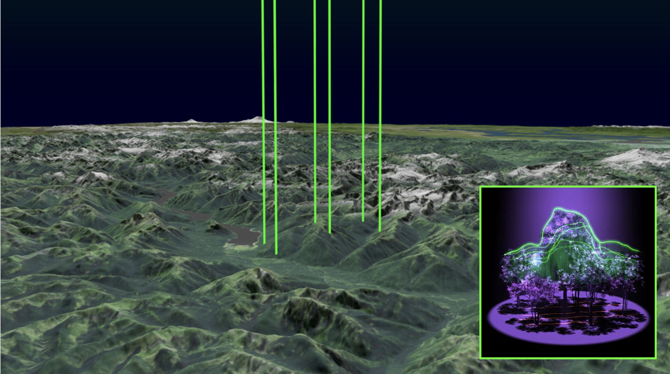
Figure 1: ICESat-2’s six beams over forested area, with tree height image inset.
Image source: NASA Scientific Visualization Studio
Clouds can present a major issue for the laser altimeter (called the Advanced Topographic Laser Altimeter System,or ATLAS) onboard the ICESat-2 satellite. While ICESat-2's laser beams can stream through some wispy clouds, most clouds will block the beams, reflecting light back to the satellite, thus making ground observations difficult, and often impossible. This may be bad news for ICESat-2’s ability to measure all the trees on Earth, but cloudy days aren’t all bad! Atmospheric scientists can use the data to gather information on the cloud heights, composition, density and more to advance the field of cloud physics.
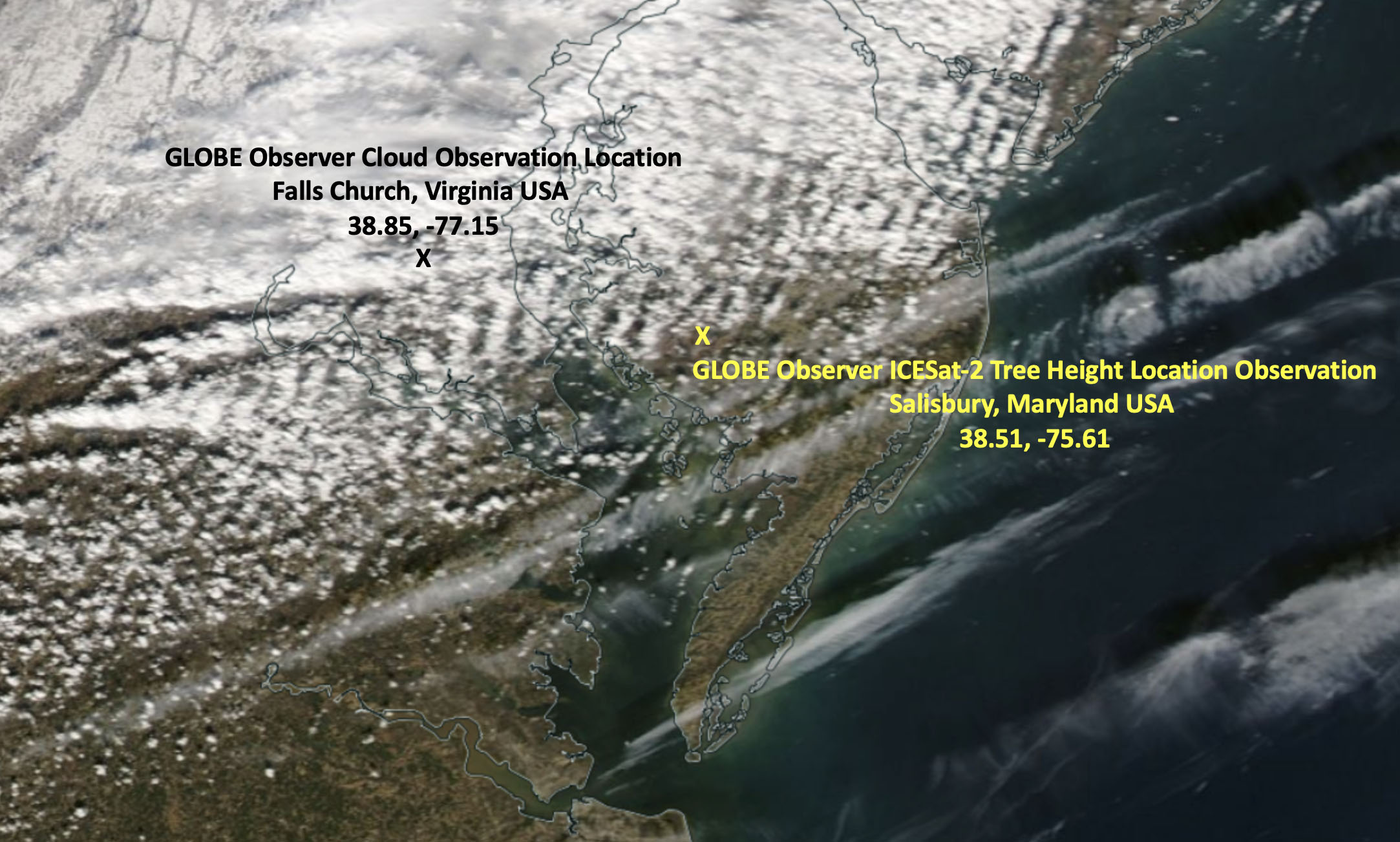
Figure 2: Cloud cover over part of the U.S. East Coast on 30 January 2019, from the Moderate Resolution Imaging Spectroradiometer – or MODIS – instrument onboard the NASA Aqua Satellite and the locations of the NASA GLOBE Observer Cloud and Tree Height observations and ICESat-2 tree canopy height observations.
Image source: NASA WorldView
As you can see from Figure 2 above, there were low-level clouds over Salisbury, Maryland, USA (location of a NASA GO tree height observation and ICESat-2 tree canopy height observation) as well as Falls Church, Virginia, USA (NASA GO Cloud Observation) on 30 January 2019. Figure 3 below, shows a NASA GLOBE Observer cloud observation and satellite (GOES-16) match over Falls Church. This same cloud system can be seen in Salisbury, Maryland.
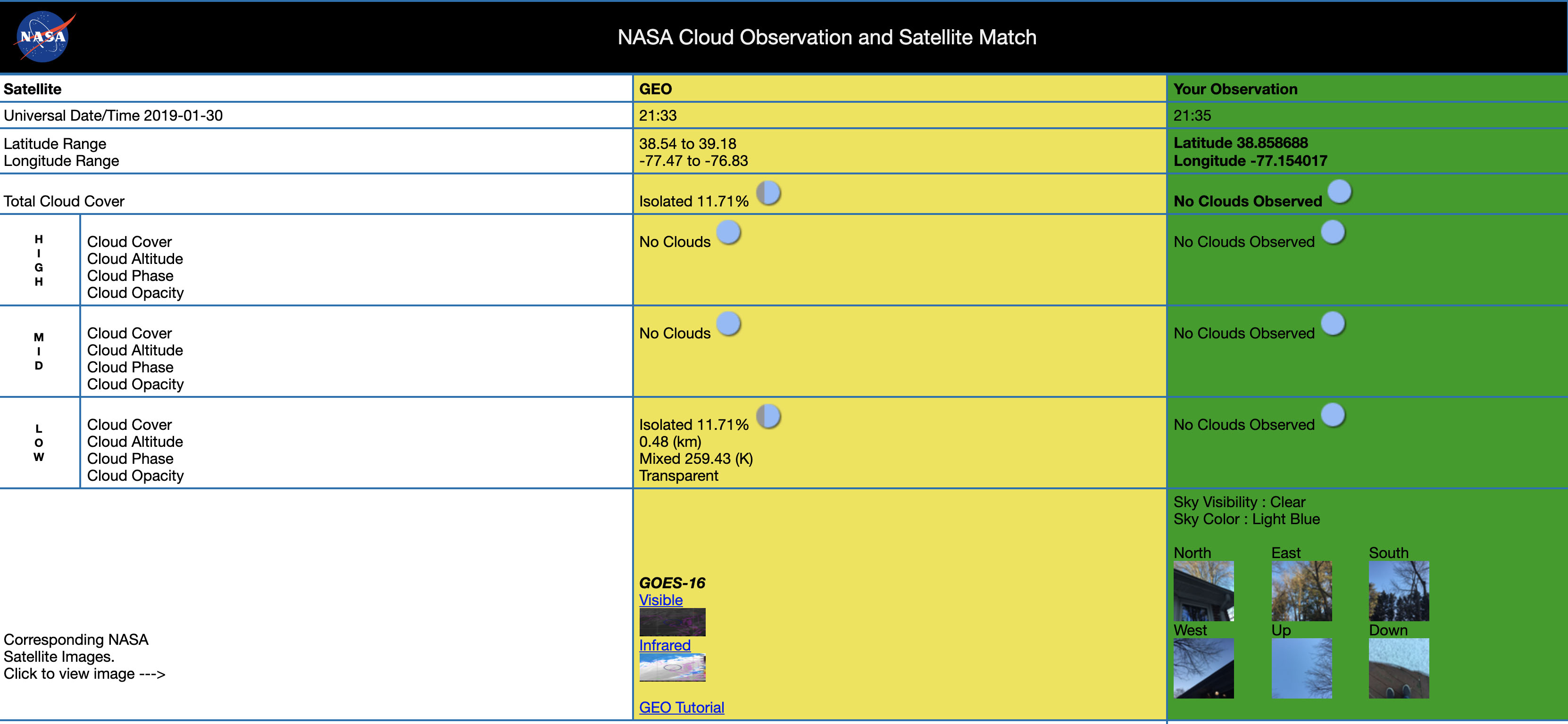
Figure 3: NASA Cloud Observation and Satellite Match for 30 January 2019
Image source: Tina Rogerson, NASA LaRC
As you may have noticed, the location match between the NASA GO cloud observation and tree height observation, as well as the ICESat-2 observation, is not exact. Looking at the latitude and longitude coordinates for each of the observations (Figure 2), the observations were taken on the same day (30 January 2019), but all three observations (NASA GO Clouds, NASA GO Tree Height, and ICESat-2 Tree Height) were not taken in the same location. This is due to the fact that both the NASA GO tree height and ICESat-2 tree height observations were at the same location and time in Salisbury, Maryland, but the nearest NASA GO cloud observation was 150 miles (241 kilometers) away in Falls Church, Virginia (see Figure 2). Even though the same cloud system appears to be over both Falls Church, Virginia and Salisbury, Maryland, the comparison results would have been better if all three observations would have been from Salisbury, Maryland.
Let’s take a look at the ICESat-2 photons (those that are returning the tree canopy heights) at the Salisbury, Maryland location. In order for ICESat-2 to maximize data quantity, quality, and accuracy, ICESat-2 emits three pairs of beams, each pair containing a strong beam and a weak beam (See Figure 1). You can see in Figure 4 below that there are missing weak-beam photons within the ICESat-2 orbit track over the tree-laden area in Salisbury, Maryland on 30 January, 2019.
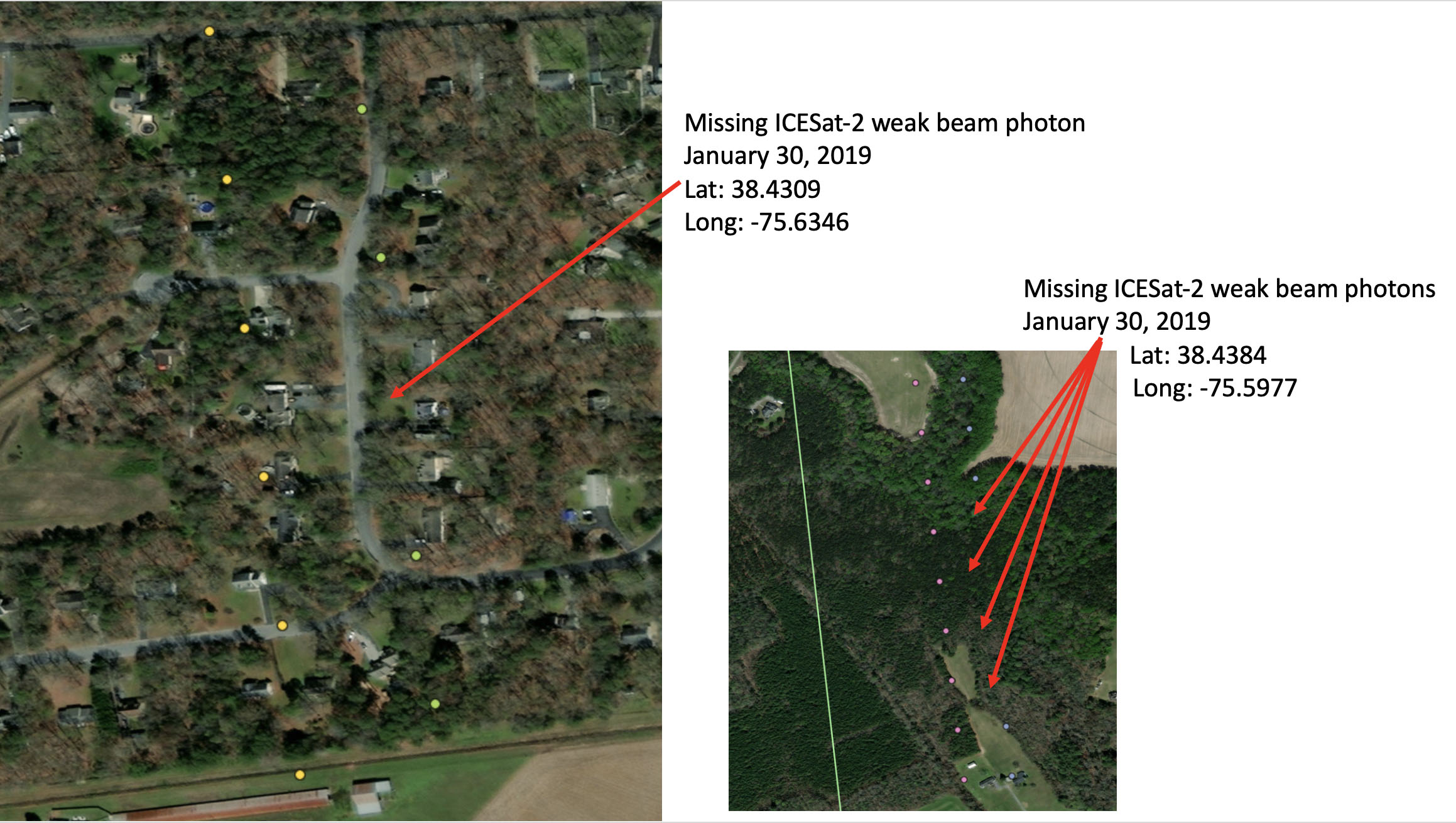
Figure 4: ICESat-2 orbit path photons over tree height observation location in Salisbury, Maryland, USA
Image source: www.openaltimetry.org
We can deduce from the available information (Figures 2 and 3), that these missing weak beam photons are most likely due to cloud cover over the specific orbit location in Salisbury, Maryland. As mentioned above, the results would be even more accurate if there would have been a NASA GO cloud observation in the Salisbury, Maryland location. The local cloud observation could have helped solidify the hypothesis that there was direct cloud cover over the tree height/ICESat-2 orbit path location, thus affecting the path of the photons from the satellite to the ground and back. This reinforces the need to take multiple NASA GO observations in the same place and at the same time, in order to know the full scope of what the data is telling us.
So, when you are out taking NASA GO cloud observations throughout the year, or during the current NASA GLOBE Cloud Challenge 2022 (15 January – 15 February, 2022), take a tree height, and maybe even a land cover observation! And remember, each observation could be the missing variable in understanding your local environment.
Brian Campbell (NASA Wallops/GST) is a NASA Senior Earth Science Outreach Specialist at the NASA Goddard Space Flight Center’s Wallops Flight Facility in Wallops Island, Virginia, USA. Brian is also the Trees Around the GLOBE Student Research Campaign Lead and the Trees Science Lead for the NASA GLOBE Observer citizen science program. Brian works with local to international students in over fifty countries.
Comments

View more GLOBE Observer news here.