Nearly every aspect of our lives is fundamentally tied to the land on which we live. The homes that shelter us are resting on the land. Cities offer locations that bring people together; farms feed us; forests help to keep us cool, provide us with oxygen, building materials, and the joys of recreation; rivers and lakes yield fresh water to drink; and different kinds of land cover provide habitats for a diversity of wildlife. When land cover changes, our health and well-being, economies, and environments can all be affected.
Land cover is a general term used to describe what is on the ground covering the land. Land cover exerts influence on weather, soil properties, and water chemistry. Different land cover types are all distinct in their effects on the flow of energy, water and various chemicals between the air and surface soil. Land cover influences the way water flows or is absorbed, potentially leading to floods or landslides. Changes in land cover matter because land cover can alter temperatures and rainfall patterns. Some types of land cover absorb carbon from the atmosphere, and when subject to changes, such as a forest burned in a wildfire, result in more carbon entering the atmosphere. Improved land cover maps will provide a better baseline to study all of these factors at both global and local scales, particularly as scientists integrate improved land cover maps into global models.
Land cover includes both developed and natural areas. All living things depend on their habitat, or land cover, for survival. They find shelter, food, and protection there. Land cover has a direct effect on the kinds of animals that will likely inhabit an area. Therefore, land cover is of great interest to ecologists, who study how plants and animals relate to their environment.
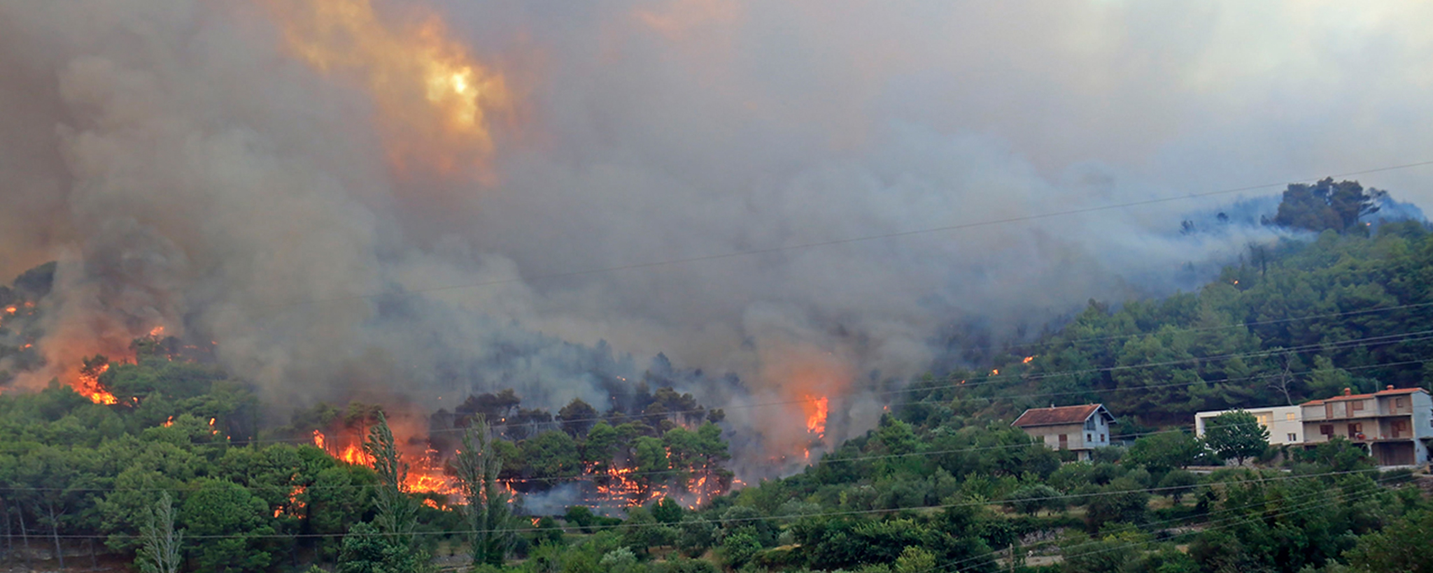
Land cover plays a big role in a community’s vulnerability to wildfire. Homes and businesses built in a landscape prone to fire are at risk of being destroyed in a wildfire. Fire agencies recommend fire buffer zones with land cover that is not highly flammable.
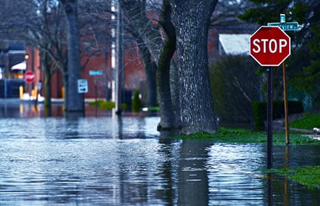
Understanding exactly how much land cover change influences floods is a question of scientific research. In general, land cover influences the way water flows across the land. When cement or even packed soil replaces a forest or wetland, water flows across the surface as run off instead of being absorbed. This change could alter the flow of rivers and/or trigger flash-flooding.
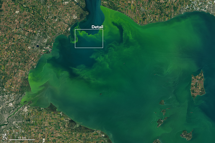
Water that flows over certain land cover types can pick up pollutants that impact a community’s water quality. Water running over cultivated land, like lawns or farms, carries fertilizers to rivers and streams. Water run-off over cement, roads, and industrial areas picks up oil, fuel, and other chemicals. Chemicals in run-off can build up in water bodies, leading to algal blooms and associated low-oxygen dead zones and generally poor water quality. This Landsat image shows an algal bloom in Lake Erie from September 2017.
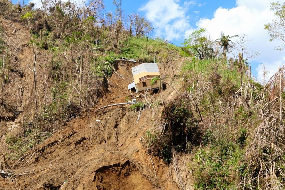
Land cover is a factor in making a slope prone to landslides. In particular, trees anchor soil, so a hill that has been cleared has a higher risk of slipping than one that has not. Bare ground, especially recently burned ground, is also more prone to erosion, which can lead to landslides.
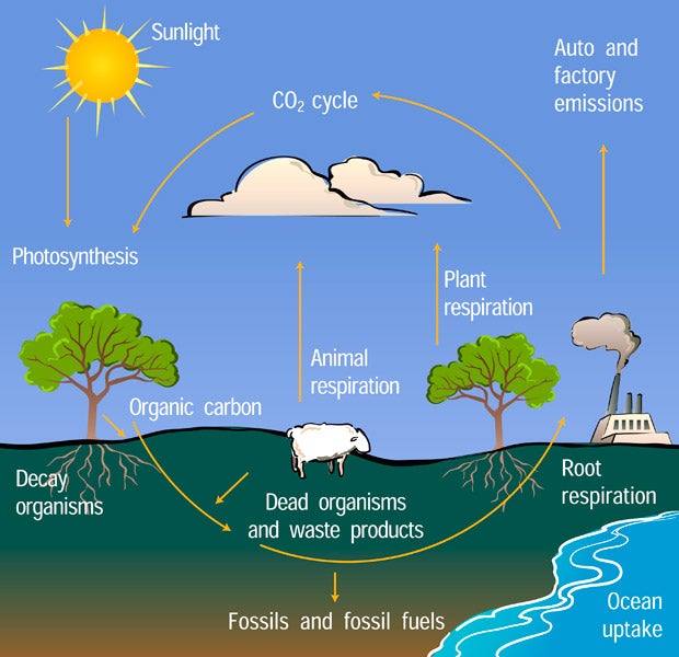
Plants absorb carbon from the atmosphere during photosynthesis. The carbon becomes part of the plant. When a plant dies, it releases that carbon back to the atmosphere. Other land cover types, such as cement or urban areas, contribute to carbon gas emissions to the atmosphere. Once in the atmosphere, carbon gases act like the thermostat controlling Earth’s climate. Land cover change can change the balance of carbon in the system. If a formerly plant-covered area is paved over, then carbon gas is added to the atmosphere and less gas is removed, since the plants are no longer there. If a barren area is reforested or other plants grow, then more carbon gas is absorbed from the atmosphere.
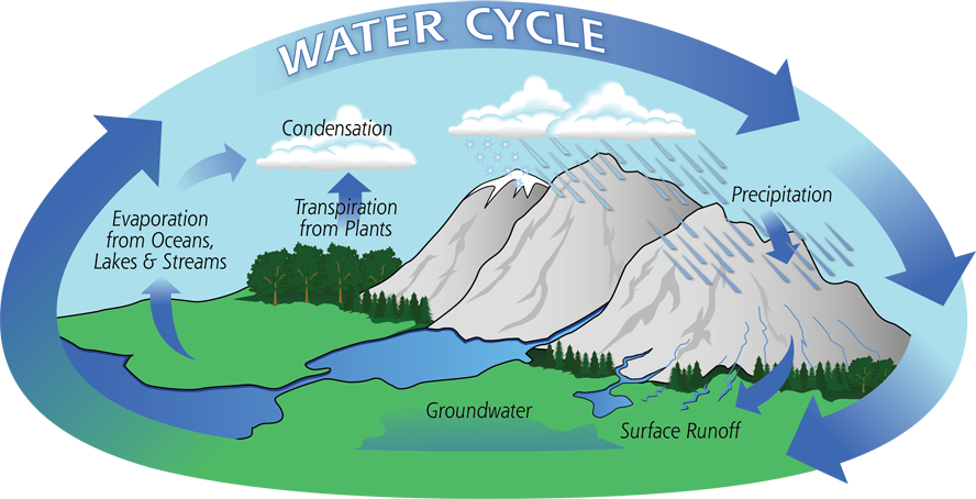
Land cover plays a role in several aspects of the water cycle. Plants absorb water from the soil and transpire water vapor to the atmosphere. Solid surfaces like rock or paved areas allow water to run across the surface, while soil and plant-covered areas tend to absorb water. A change in land cover can change how much water is absorbed into the ground vs how much flows into rivers.
Plant-covered land is usually cooler than other kinds of land cover. Energy from the Sun heats the surface, but plants take in that energy along water and carbon to produce food through photosynthesis. That means that plant-covered land doesn’t heat up as much as other surfaces. Plants also release water vapor and oxygen as a part of photosynthesis. Just as misters cool you off on a hot summer day, the water vapor cools the land and air.
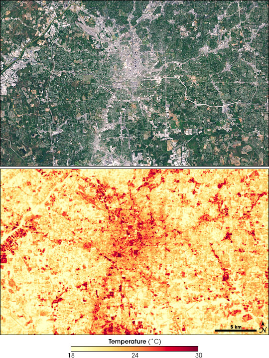
Different materials absorb sunlight and radiate heat in different ways. Materials used in cities or residential areas, such as cement, metal, and asphalt, radiate more heat than plant-based land cover. As a result, cities can be as much as 8 degrees warmer than suburban or natural landscapes, a phenomenon known as urban heat island. This image was made from Landsat-7 satellite observations. It shows Atlanta in photo-like natural color (top) and as a heat map. The cement-colored city is much warmer than the surrounding area. Urban heating is great enough to influence rainfall patterns.
For years, scientists across the world have been mapping changes in the landscape to prevent future disasters, monitor natural resources, and collect information on the environment. The most efficient way to map land cover is from space. By using such imaging satellites as Landsat, Aqua and Terra, scientists have the ability to observe large tracts of the Earth's surface in a fraction of the time needed to complete aerial or ground surveys.
Satellites measure the amount of energy reflected by the Earth’s surface in multiple regions of the electromagnetic spectrum, including regions beyond what the human eye can see. Collecting this data over time can help us document the changes taking place. Satellites can be our “eyes” in the sky (or orbit). Remote sensing in space has the great advantages of being able to cover very large areas quickly and to revisit the same area frequently. However, some of the detail that can be seen at ground level may not be detected by a remote sensing system. Therefore, there is a need for actual ground observations to accompany these data. Ground observations, such as those using the GLOBE Observer: Land Cover tool and other GLOBE Biosphere protocols, can provide reference data to help scientists interpret satellite data, improving the accuracy of maps created from remote sensing data and other products.
The most detailed satellite-based maps of global land cover are on the order of hundreds of meters per pixel, which means that small details may not show up. For example, a park in a city may be too small to show up on the global map. The Land Cover tool (also known as Adopt-a-Pixel) provides ground-based comparison data for such land cover maps, among other purposes, through photographs taken with a smartphone or other device, as well as classifications by citizen science observers of the types of land cover they see in those images.
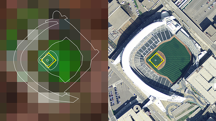
Data from satellites are recorded and converted into digital images composed of picture elements (pixels) arranged in columns and rows. Different satellites have different sizes of pixel. For example, the pixels from Landsat satellite observations cover an area of about 30m by 30m of the Earth’s surface (about the size of a baseball diamond, see image below), while the Moderate Resolution Imaging Spectroradiometer (MODIS) instrument on the Aqua and Terra satellites has a pixel size of up to 250m by 250m for measurements in the visible range of the spectrum. Both Landsat and MODIS data can be used to derive a satellite-based map of land cover.
Maps help us understand where things are. Scientists use satellites to make maps of many different things on Earth to help them understand our world and how our world is changing. When mapping land cover, scientists use many different classification systems to differentiate what is on the land. This map, created from MODIS data, divides land cover into 17 different categories, such as cities, farm lands, forests, deserts, and so forth. The different colors on this map show the locations of each type of land surface. Scientists are monitoring how these land cover types change over time.
The science lead for the Land Cover tool, Peder Nelson, gives updates about recent research being done using the data collected via the GLOBE Observer app. (Originally aired during the GLOBE Observer Connection-Conversation-Celebration event held 26 July 2022.)
Your observations of land cover complement land cover data from satellites. While satellites see the ground from the top down, your view of the land includes height, details and layers. You are also able to record land cover when clouds block the view from space.
Having the ground observations can confirm the land cover type as assessed by analyzing satellite data, identify areas where change has occurred, and fill in gaps or fine details not easily visible from the satellite.
GLOBE aligns your ground observations of the land to images and data products from instruments on the Terra, Landsat, and Sentinel satellites. We compare your observations to the most recent Landsat and Sentinel-2 images and the Terra MODIS land cover classification product.
When to collect data for a satellite comparison
Landsat 8 and 9 together image the entire globe every eight days and Sentinel 2 every five days. This means that the image closest in time to your observation may be as much as eight days in the past. You can collect land cover observations when a Landsat satellite is overhead to receive an image from the same day. This is useful because you are recording the same light and shadow conditions and cloud cover that the satellite is seeing.
Observations taken between satellite overpasses are also useful. You may capture the timing of an event that occurs quickly that might be missed otherwise. You can see quick changes like leaf out during seasonal change or the impact of a storm.
About the Satellites and Data Products
Landsat 8 & 9:
In collaboration with USGS, NASA launched the Landsat 9 satellite in 2021 to join Landsat 8 in surveying, studying, and mapping the Earth’s surface from space. Landsats 8 and 9 can image the entire globe within 8 days at a resolution of 30 meters per pixel. The Landsat 8/9 image provided in the Satellite Comparison Table displays the most recent image from either satellite relative to the recorded time of observation. Learn more about Landsat 8 and 9.
Artistic renderings of Landsat 8 (left, launched in 2013) and Landsat 9 (right, launched in 2021), from the Landsat Science page.
Sentinel 2:
The Copernicus Sentinel-2 mission conducted by the European Space Agency (ESA) consists of three satellites - Sentinel-2A, Sentinel-2B, and Sentinel-2C - launched in 2015, 2017 and 2024 respectively. Similar to Landsat 8 and 9, these satellites operate on opposite sides of the Earth to together provide coverage of the entire globe every 5 days at a resolution of 10 meters per pixel. The Sentinel-2 satellites assist the ESA in studying land and agriculture and support security concerns and risk management. The Satellite Comparison Table includes the most recent image from either Sentinel-2 satellite relative to the observation time. Learn more about Sentinel-2.
The MODIS Instrument:
MODIS (Moderate Resolution Imaging Spectroradiometer) is an instrument aboard the Terra satellite. MODIS images the entire Earth’s surface every one to two days at a resolution of 250 meters per pixel. MODIS data is used in a variety of studies, including vegetative health, ocean biology, sea surface temperature, cloud analysis, and even monitoring natural disasters like wildfires. Learn more about MODIS.
By analyzing MODIS data, scientists can classify land cover globally. These land cover descriptions can be compared to the MUC codes calculated from the land cover types (optionally) reported during GLOBE Land Cover observations.
What does the comparison mean?
In your satellite comparison table, we provide the MODIS classification class for your location (see example at right). Your classification may not match the MODIS land cover classification exactly. The MODIS land cover data product calculates land cover for every 500 square meters of Earth’s surface, or at a resolution of 500 meters per pixel. Your observation covers an area of about 100 meters. If the area you observed is different from the surrounding area - say a park in a city, then your correct classification won’t match the MODIS classification for the larger area, which is also correct. Additionally, the land might have changed since the MODIS land cover product was generated.
Landsat and Sentinel 2 images are a natural color view of the ground similar to what your eyes might see from above. These images are a snapshot in time, which means they may be cloudy. If you’d like a clear view of the ground, we encourage you to collect data on a clear day when a Landsat satellite is overhead. See an example of the Satellite Images section of the comparison table below.
Accessing Satellite Comparisons
There are multiple ways to access your satellite comparison tables. If you opt in to receive NASA satellite images (tap the gear icon in the lower right of the app, then select the "Opt-in/Opt-Out Settings" button to view and change your settings), you will receive an email within a few days with corresponding satellite data.
In addition to the emails, you can also access your satellite comparisons via the My Observations page when logged in to your GLOBE account on a computer, and from within the GLOBE Observer app. See detailed instructions for how to get to your satellite comparsions (for both Land Cover and Clouds observations) on the How to Access Satellite Comparisons page.
Do GO - LC Science - Satellite Forest Data
Example of Satellite Data About Forests - Video
For the North American Forest Dynamics study, scientists combined 25 years of satellite data from the joint U.S. Geological Survey/NASA Landsat satellite program with information from the U.S. Forest Service to highlight where forest canopy was disturbed. This video shows how annual maps of the lower-48 United States produced from satellite data illustrate how these dynamic systems changed from 1986-2010. Logging and hurricanes play a significant role in the Southeast, and fires and insect invasion damage forest canopy in the West.
Scientists and land managers must have accurate pictures of the land and how it’s changing in order to understand and manage the land. Land cover data gathered by satellites and other means helps provides a big-picture, long-term view. Comparing land cover data from one year to the next helps people evaluate how a community’s past land management efforts are working and can provide valuable information on trends to help in planning for the future.
Land cover is part of Earth systems that work together like cogs in an engine.
Plants covering the land are a critical component of the carbon cycle.
Land cover influences the water cycle.
Land cover influences heating and cooling.
Carbon, water, and energy are part of Earth’s climate system. Changes in land cover can contribute to climate change and climate change results in changes to land cover.
Scientists compare citizens’ observations with the data from remote sensing satellites. This way scientists and others can improve the accuracy of their assessments and improve maps of current conditions and past changes. The data also helps to project conditions of the land in the future.
Land cover studies are part of a broad program by NASA to monitor Earth’s vital signs from land, air and space using an array of satellites and instruments on the International Space Station to better understand our home planet. The agency tackles some of the biggest challenges facing our planet today and in the future, including natural disasters, the availability of natural resources, rising sea levels and climate change. NASA’s planetary perspective means that we study the systems that work together to sustain life on Earth.
Land cover maps can be created with data from many different satellite sensors, including MODISand Landsat. Satellite-based land cover maps are combined with ground-based observations and models to study the location, extent, cause, processes, and consequences of change. See NASA’s Land Cover Land Use Change Programfor details.
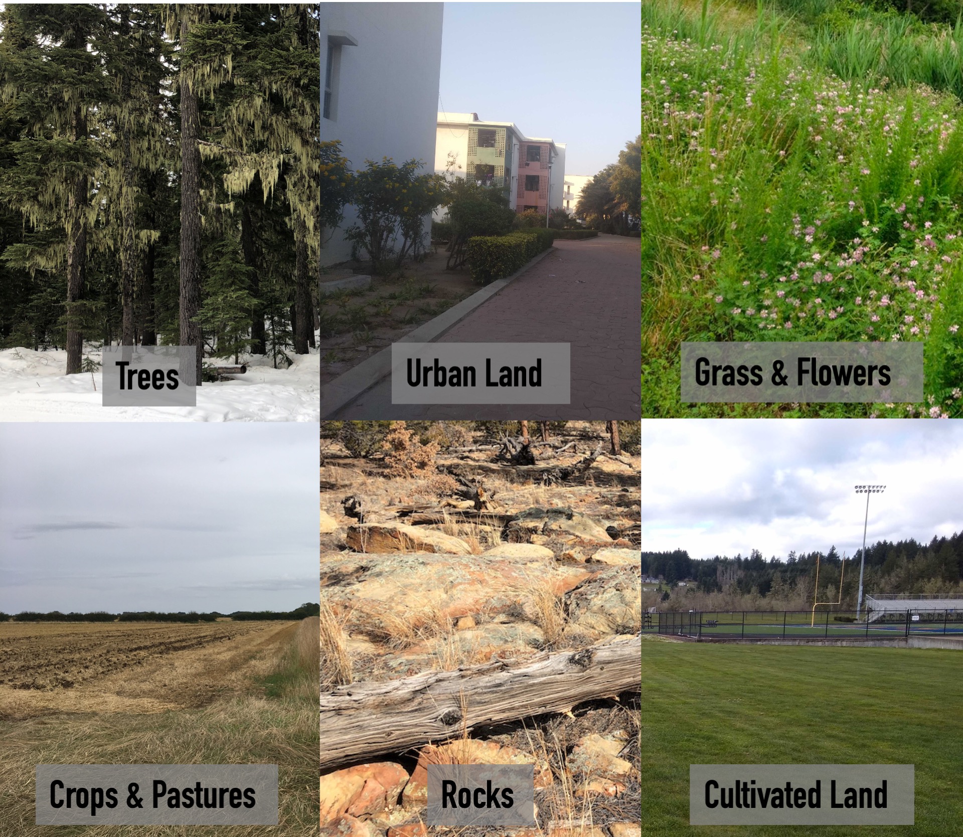
Land cover types are simply categories of landscapes that scientists are trying to map for different kinds of studies. Because the scientific questions being asked are different from one another, the ways scientists categorize landscapes are different from one another; they can vary from study to study and map to map. For example, for flood maps there may be only two categories–dry land and wet land–while the MODIS global land cover map may have seventeen categories including closed shrub lands, savannas, evergreen needle leaf forest, urban areas, and ice/snow. The only requirement for any land cover category is that it have a distinct spectral signature that a satellite can record.
The several classes of land cover in GLOBE Observer were chosen to work well for most needs of scientists who work with the land cover data collected by Landsat instruments and by NASA’s Moderate Resolution Imaging Spectroradiometer (MODIS). They also align with land cover classes used in the GLOBE Program.
The two terms land cover and land use are often used interchangeably, but in fact land cover refers to what covers the surface of the Earth, whether it is vegetation (such as grasses, shrubs, forests, agricultural crops), pavement, buildings, or bare ground. Land use refers to how the land is being used—whether for agricultural, recreational, residential, commercial, or industrial purposes. The same types of cover can be managed or used very differently.
Do GO - LC Science - Publications
Publications Related to GLOBE Land Cover
For a more complete list of GLOBE Observer publications and presentations, visit the publications page.
Patil, Y., Fathima, R., Campbell, B., Janney, D., Hudnurkar, S., & Harikrishnan, R. (2024). Review of earth observation techniques and citizen science approach for biodiversity hotspot study. International Journal of Environmental Impacts, 7(4), 753-767. https://doi.org/10.18280/ijei.070416
Nelson, P. V., Low, R., Kohl, H., Overoye, D., Yang, D., Huang, X., Chellappan, S., Azam, F. B., Carney, R. M., Falk, M., Garriga, J., Schelkin, L., Boger, R., & Schwerin, T. (2024). GLOBE Observer: A case study in advancing Earth system knowledge with AI-powered citizen science. Citizen Science: Theory and Practice, 9(1), 33. https://doi.org/10.5334/cstp.747
Abdelkader, M., Bravo Mendez, J., Temimi, M., Brown, D., Spellman, K., Arp, C., Bondurant, A., & Kohl, H. (2024). A Google Earth Engine platform to integrate multi-satellite and citizen science data for the monitoring of river ice dynamics. Remote Sensing, 16(8), 1368. https://doi.org/10.3390/rs16081368
Hobeika, M., Dawalibi, V., Kallas, G., & Russo, A. (2024) Evaluating the Landscape and Ecological Aspects of Urban Planning in Byblos: A Multi-Faceted Approach to Assessing Urban Forests Land, 13(4), 464. https://doi.org/10.3390/land13040464
Huang, X., Yang, D., He, Y., Nelson, P., Low, R., McBride, S., Mitchell, J., Guarraia, M. (2023) Land cover mapping via crowdsourced multi-directional views: The more directional views, the better. International Journal of Applied Earth Observation and Geoinformation, 122. https://doi.org/10.1016/j.jag.2023.103382.
Manzanarez, S., Manian, V., & Santos, M. (2022). Land use land cover labeling of GLOBE images using a deep learning fusion model. Sensors, 22(18), 6895. https://doi.org/10.3390/s22186895
Low, R. D., Nelson, P. V., Soeffing C., Clark A., & SEES 2020 Mosquito Mappers Research Team. (2021). Adopt a Pixel 3 km: A multiscale data set linking remotely sensed land cover imagery with field based citizen science observation. Frontiers in Climate, 3. https://doi.org/10.3389/fclim.2021.658063
Kohl, H.A., Nelson, P.V., Pring, J., Weaver, K.L., Wiley, D.M., Danielson, A.B., Cooper, R.M., Mortimer, H., Overoye, D., Burdick, A., Taylor, S., Haley, M., Haley, S., Lange, J., & Lindblad, M.E. (2021). GLOBE Observer and the GO on a Trail data challenge: A citizen science approach to generating a global land cover land use reference dataset. Frontiers in Climate, 3. https://doi.org/10.3389/fclim.2021.620497
Boger, R., Low, R., & Nelson, P. (2020). Identifying hurricane impacts on Barbuda using citizen science ground observations, drone photography and satellite imagery. International Archives of Photogrammetry, Remote Sensing and Spatial Information Sciences, XLII-3/W11, 23-28. https://doi.org/10.5194/isprs-archives-XLII-3-W11-23-2020
Amos, H. M., Starke, M. J., Rogerson, T. M., Colón Robles, M., Andersen, T., Boger, R., Campbell, B.A., Low, R.D., Nelson, P., Overoye, D., Taylor, J. E., Weaver, K. L., Ferrell, T., Kohl, H., & Schwerin, T. G. (2020). GLOBE Observer Data: 2016–2019. Earth and Space Science, 7(8). https://doi.org/10.1029/2020EA001175
Weaver, K., Davis A., & Giddens, J. (2019, September/October). Can an app change how you see the world? GLOBE Observer for interpreters. Legacy: The magazine of the National Association for Interpretation, 30(5), 20-23.