


Land Cover Resource Library - GLOBE Observer


Land Cover Resource Library


All Year Long Science Journal Activity
This activity shows how students will keep a science journal during each of the four seasons. Students will record observations of the general outdoor environment they visit and then will make observations of one specific item from the habitat in each season. At the end of the school year, students will make comparisons of their seasonal drawings and share their results with the class.
EO Kids: All the Colors of the Leaves
Explore in the colors of the leaves in this activity from page 3 of this EO Kids issue about how NASA sees the seasons change from space.
See how glaciers carve the landscape using sand, cornstarch and water in this activity on page 3 of the EO Kids issue about Glaciers.
See how earthquakes and intense rain can trigger landslides through a hands-on activity from this issue of EO Kids.
EO Kids: Mini Urban Heat Island
Use an infrared thermometer to record the temperature of different materials at different times to explore the urban heat island effect on page 13 of this issue of EO Kids.
Build a land cover map using blocks or LEGO bricks.
An activity to guide you through making a map, including deciding on a purpose for the map, and adding elements such as a grid, a compass, a scale, a key, symbols, and labels that show how different things relate to each other.
This activity allows you to make more detailed and quantitative measurements along four transects of a 50m by 50m square observation area (pixel) that can be compared with the percentages estimated using the GLOBE Observer: Land Cover tool and satellite-based maps.
Land Cover Type Quick Reference Guide
Review different land cover types using this handy reference sheet, including example photos and tips.
[3:57] Forests are an important part of the carbon cycle. This video shows how the Landsat satellites are used to track changes in forests.

GLOBE Observer: Land Cover - Getting Started
[2:44] Learn how to take land cover observations using the GLOBE Observer app.
[1:39] Highlights video of observations along the Lewis and Clark National Historic Trail from Pennsylvania to Oregon taken during the GO on a Trail challenge held from June 1st to September 2nd, 2019.
Introducing GLOBE Observer Land Cover
[0:49] This short video introduces the Land Cover: Adopt-a-Pixel tool in the GLOBE Observer app.
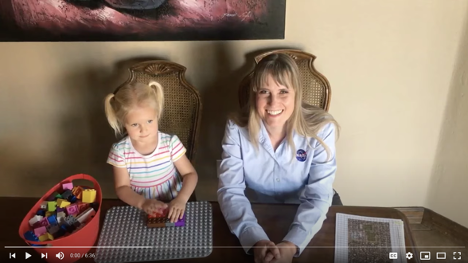
[6:34] Holli Kohl, project coordinator for GLOBE Observer, and her daughter will guide you through how to replicate a land cover map from space with some LEGOs, as well as show you how you can make real-world land cover observations using the NASA GLOBE Observer app.
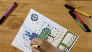
[9:00] A video demonstrating the "Making a Map" activity, which guides you through making a map, including deciding on a purpose for the map, and adding elements such as a grid, a compass, a scale, a key, symbols, and labels that show how different things relate to each other.
NASA eClips: Dr. Lola Fatoyinbo Agueh
[1:51] Dr. Lola Fatoyinbo Agueh, a Research Physical Scientist at NASA's Goddard Space Flight Center, shares her journey from her childhood to current career in a video from NASA eClips.
NASA eClips Real World: The Carbon Cycle
[5:43] Carbon is an essential building block for life. Learning how carbon is converted through slow- and fast-moving cycles helps us understand how this life-sustaining element moves through the environment. Discover how NASA measures carbon through both field work and satellite imagery keeping watch through its eyes on the sky, on Earth, and in space.
Tracking Urban Change with Landsat
[3:10] This video explains how FEMA uses information about urban changes from Landsat satellite data to help determine flood risks.
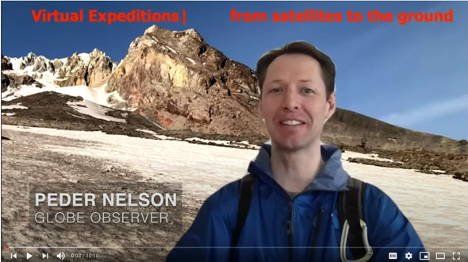
Virtual Expedition: Mapping and Land Cover
[10:10] Go on a virtual expedition with NASA GLOBE Observer Land Cover science lead Peder Nelson and learn about how you can explore your world and your land with various online tools.
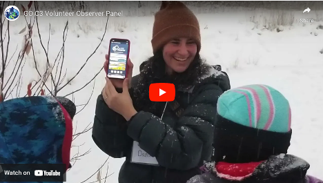
Volunteer Scientist Panel Video
[11:10] A video showcasing stories from GLOBE volunteers about how they got started with GLOBE and the GLOBE Observer app, and connections they have made to research and to using GLOBE in their communities. This was originally shown as part of the GLOBE Observer Connection-Conversation-Celebration (C3) event held on 26 July 2022.
[7:41] This video explains what land cover is, why scientists use land cover observations from satellites, as well as why they need help from citizen scientists to collect data.
Books
Use WorldCat to search libraries near you, read reviews, and find editions in different languages.
Land Cover Books for Teens and Adults
Land Cover Introductory Tutorial
The short animation from the introduction to the Land Cover tool in the GLOBE Observer app, explaining the basics of how to make observations.