News - GLOBE Observer
3 Years of ICESat-2 and NASA GLOBE Observer Tree Heights

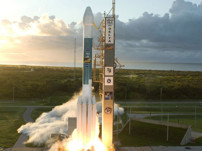
The launch of ICESat-2 from Vandenberg Air Force Base on September 18, 2015. Photo courtesy of NASA.
Three years ago, on September 15, 2018, at 6:02 a.m. PDT, NASA launched the Ice, Cloud, and land Elevation Satellite-2 or ICESat-2 from the Vandenberg Air Force Base (now the Vandenberg Space Force Base) in Lompoc, California.
Launched aboard the last Delta II rocket, ICESat-2, has spent the last three years taking measurements of our planet's frozen and icy areas, called the cryosphere. ICESat-2 helps scientists investigate our changing cryosphere in a warming climate. A benefit for all of us using the NASA GLOBE Observer, ICESat-2 also measures the heights of Earth’s trees, forests, and vegetation worldwide, providing data that can directly correspond to GLOBE Observer’s Trees Tool observations.
ICESat-2 carries an onboard laser altimeter system called the Advanced Topographic Laser Altimeter System or ATLAS. The ATLAS instrument fires laser pulses – 10,000 per second – toward the Earth from 310 miles (498 kilometers) above. Scientists can determine the heights of Earth’s features, like ice sheets, sea ice, oceans, buildings, trees ¬– among other things – by calculating the time it takes for the laser photons to leave the satellites, hit the Earth, and return to the satellite. By doing this repeatedly, scientists can see of the height of the Earth objects are changing over time. Over the last three years in space, ICESat-2 has potentially measured the heights of 1 billion trees.
With all these tree canopy/tree height observations from ICESat-2, surely there has to be areas on Earth where both ICESat-2 and GLOBE observers took tree height observations of the same trees. Since ICESat-2 takes tree height observations from space and GLOBE citizen scientists take tree heights from the ground, there is great potential to do tree height comparisons between the two sources of tree height data.
When the laser photons leave the satellite and travel the 310 miles (498 kilometers) to Earth, the photons that reach the Earth create a 13-meter diameter footprint on the object’s surface.
What does this mean? If the photon hits a forested area and bounces off 25 trees contained within that 13-meter diameter footprint, the tree (canopy) height returned from ICESat-2 will be the average of all 25 trees. If there happens to only be a single tree in a photon footprint, the tree height returned from ICESat-2 will be just the height of that tree. Getting the average height of multiple trees is a lot more common than getting the height of an individual tree, but it can be done!
Below are some examples of ICEat-2 tree heights and GLOBE trees heights for groups of trees and individual trees, from Salisbury, Maryland, USA.
ICESat-2 and NASA GLOBE Observer Tree Height Comparison for Groups of Trees
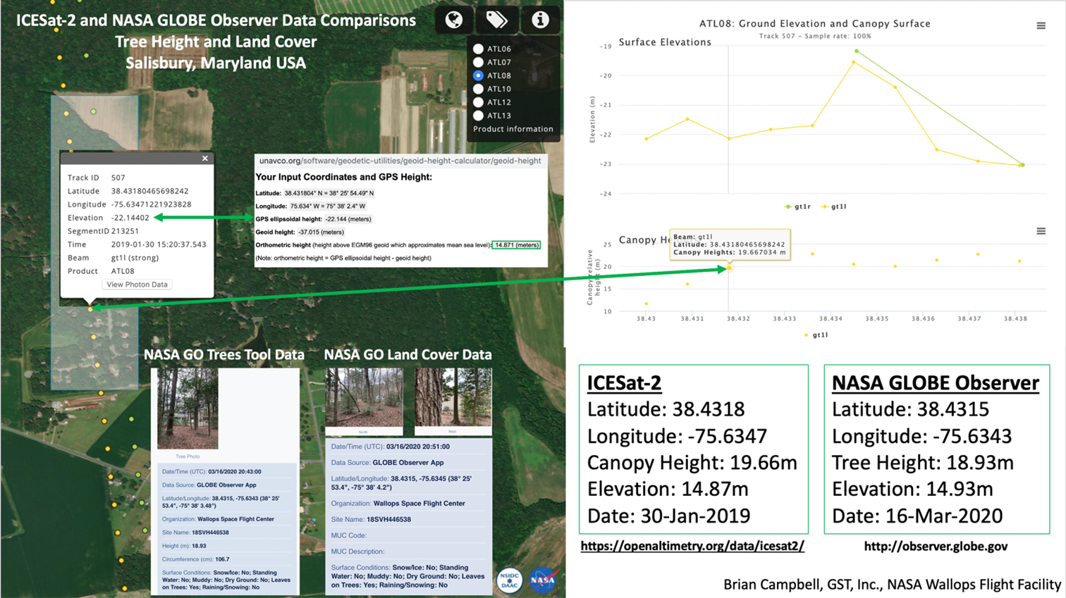
On January 30, 2019, the ICESat-2 satellite took tree canopy height observations at latitude 38.4318, longitude -75.6347. Within the 13-meter diameter photon footprint, there were eight trees, resulting in an average canopy height of 19.66m. The author took NASA GO tree height observations of each of these trees and chose the one that best represented the overall average of the 8 trees heights. You can see that below as 18.93 meters. This resulted in only a difference of 0.73 meters about the height of a standard desk lamp. Not bad!

Comparing ICESat-2 and NASA GLOBE Observer tree heights for
groups of trees.
ICESat-2 and NASA GLOBE Observer Tree Height Comparison for an Individual Tree
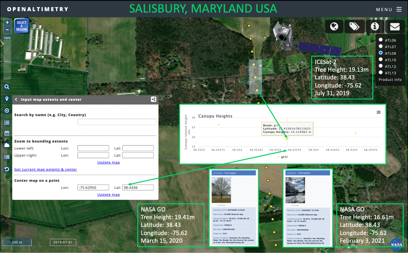
On July 31, 2019, the ICESat-2 satellite took tree canopy height observations at latitude 38.4312, longitude -75.6295. Within the 13-meter diameter photon footprint, there was an individual Bradford Pear Tree, with an ICESat-2-measured height of 19.13 meters. The author took a NASA GO tree height observation, on March 15, 2020 and got a tree height of 19.41 meters. This resulted in only a difference of 0.28 meters. Another close comparison.

Comparing ICESat-2 and NASA GLOBE Observer tree heights for an
individual tree.
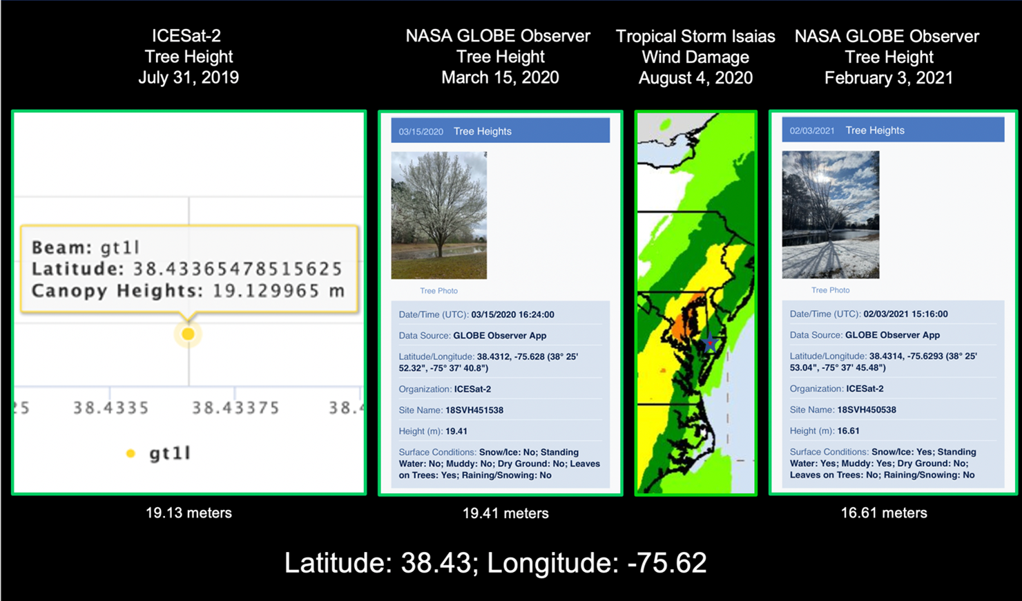
On August 4, 2020, when the remnants of Tropical Storm Isaias brought winds in excess of 70 mph (112 kmh), the Bradford Tree broke in half, decreasing the height of the tree by almost 3 meters to 16.61 meters. The next step is for ICESat-2 to hopefully measure this tree again in the future so that another comparison can be done.

Comparing ICESat-2 and NASA GLOBE Observer tree heights for an
individual tree after Tropical Storm Isaias.
The last 3 years of ICESat-2 tree height measurements, combined with the 50,000+ tree height observations from GLOBE Program participants, showcases the importance of both the space-based tree height and ground-based observations. Comparing these observations provides student and professional researchers with a robust data set for analyzing tree heights on Earth. Even though we will most likely never be able to measure all 3 trillion+ trees’ heights on Earth, the data from both ICESat-2 and NASA GLOBE Observer is providing vital data that helps our planet’s researchers understand Earth’s carbon budget, tree cover, and how our planet is changing over time in response to a changing climate.
Keep looking up at the trees!
Brian Campbell (NASA Wallops/GST) is a NASA Senior Earth Science Outreach Specialist at the NASA Goddard Space Flight Center’s Wallops Flight Facility in Wallops Island, Virginia USA. Brian is also the Trees Around the GLOBE Student Research Campaign Lead and the Trees Science Lead for the NASA GLOBE Observer citizen science program. Brian works with local to international students in over fifty countries.
Comments
View more GLOBE Observer news here.


