News - GLOBE Observer
Is That a Mosquito Habitat?
The GLOBE Mosquito Habitat Photo Challenge kicked off Sunday, July 25 and continues through August 25, 2021. This challenge combines Mosquito Habitat Mapper and Land Cover (two GLOBE Observer app tools) to document areas with and without mosquito breeding habitats using only photos.
A picture could be worth a thousand words. But can we use computers to tell us which words describe the content of photos? Your photo contributions could help us answer this question while supporting new NASA research projects.

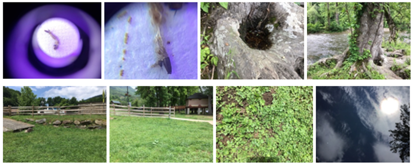
Image 1. From left to right, include examples of GO photos that could be described with words like mosquito larva (with a spindle-shaped siphon), mosquito habitat (tree hole), land cover (grass, pasture, road), and sky (sun, clouds, tree canopy).
A Computer Must Be Trained To See
There has been incredible growth in using computer vision algorithms for object detection. But how well do these algorithms identify different land cover elements or mosquito larvae types? And which one(s) would work best? Those questions can only be answered with a large amount of photos that not only show mosquitoes and their associated land cover habitats, but also photos that are not mosquito habitats. That is where your photo contributions could make a difference.
NASA is funding research to automatically detect and label GLOBE Observer Land Cover and Mosquito Habitat Mapper photos. Four groups were selected via a competitive process, receiving support for one year of Rapid Response Research (R3). The science leads for the GLOBE Observer Land Cover tool (Peder Nelson, M.S.) and GLOBE Observer Mosquito Habitat Mapper (Dr. Russanne Low) are working as science mentors with these four research groups.
- New Mexico State University
- University of Puerto Rico, San Juan
- University of Vermont, Burlington
- University of Wyoming
You can read the all of the abstracts here.
Do You Have Photos On The Map?

These R3 research teams rely only on citizen science photos to create automated approaches for identifying objects like mosquito larvae and different land cover types. Identification success requires variety, like the photos seen on the GLOBE Visualization System map. On this map, you see a variety of land cover elements like open water, urban buildings, closely spaced trees, loosely spaced trees, bare ground with boulders, bare ground with sand, natural grasslands, cultivated grasslands, and even the artificial turf that are green to our eyes and cameras.
Put Your Photos On The Map
Collaborative science will only work if you participate. So whether you find mosquitoes or not during this photo challenge, use GLOBE Observer to record the land cover of your location! Mosquitoes require particular land cover conditions to survive. Broadly, locations with a presence of water and vegetation are typically where you might find mosquito habitat. But you might surprise us with what you find. Using the two GLOBE Observer tools together, allows all of us to document and archive present conditions. If there are not any mosquitoes in a location, use the GO Mosquito Habitat Mapper tool to add a photograph and record zero larvae. Then take a GO Land Cover observation of the broader landscape.
By working together to photograph the world around us, we could help create new citizen science knowledge and tools that will benefit us all – benefits like identifying dangerous disease carrying mosquito breeding grounds and eradicating them. Learn more about doing NASA science and participating in the challenge!
Peder Nelson M.S., is the Land Cover science lead for GLOBE Observer. In addition, he is an Instructor of Geography and Geospatial Science and researcher in the Environmental Monitoring, Analysis, and Process Recognition (eMapR) Lab in the College of Earth, Ocean, Atmospheric Sciences at Oregon State University. With a background in environmental education, biological sciences, and land management, he uses remote sensing and geographic information systems to create maps and data that show people what is happening on planet Earth, particularly changes that can be seen from space. Twitter: @pedervnelson and http://emapr.ceoas.oregonstate.edu/
Comments
View more GLOBE Observer news here.


