News - GLOBE Observer
Five Years of ICESat-2, GLOBE Trees, and the Trees Around the GLOBE Student Research Campaign
Over the last five years, observations of tree height have become a major observation within The GLOBE Program. This is primarily due to several things: The launch of the NASA Ice, Cloud, and land Elevation Satellite-2 or ICESat-2, the start of the Trees Around the GLOBE Student Research Campaign, the release of The GLOBE Program’s GLOBE Observer Trees tool, and the ability to compare ground-based tree height observations, from GLOBE, to space-based observations of Earth’s tree heights from the NASA Ice, Cloud and land Elevation Satellite-2 or ICESat-2. In this blog, we will explore these various programs and methods of measuring and making sense of tree height observations through historical information, observations, and data metrics over the last five years.

About the Ice, Cloud, and land Elevation Satellite-2 (ICESat-2)
It’s been five years –
The ICESat-2 mission was launched into space on 15 September 2018 from the Vandenberg Air Force Base (now the Vandenberg Space Force Base). ICESat-2 carries a photon-counting laser altimeter that allows scientists to measure the elevation of ice sheets, glaciers, sea ice and more – all in unprecedented detail, one laser pulse at a time, 10,000 laser pulses a second.

ICESat-2 and Trees
Even though ICESat-2 observations focus on the Earth’s icy, polar regions, ICESat-2 has also been measuring the height of trees across the planet for the last five years with its ATLAS instrument, adding a third dimension to flat images of Earth from space. Other Earth-observing satellites, such as Landsat and MODIS, allow researchers to study the location and extent of forests across the planet. However, the onboard Advanced Topographic Laser Altimeter System (ATLAS) instrument is sensitive enough to detect individual photons, and has such a rapid firing rate, the instrument detects both the forest floor and the tops of canopies in all but the densest woods and jungles. According to recent calculations, ICESat-2 has observed the heights of approximately 1.6 TRILLION TREES across the planet, over the last five years! WOW!

Five Years of GLOBE Trees
Even though The GLOBE Program’s GLOBE Observer app’s Trees tool was released on 26 March 2019, there have already been an amazing amount of tree height observations coming into the GLOBE database through the app and from students and educators using the traditional method of a hand-held clinometer. Since 15 September 2018, there have been 80,000+ tree height observations from 28,000+ locations across the globe.
Five Years of the Trees Around the GLOBE Student Research Campaign
The Trees Around the GLOBE Student Research Campaign, focusing primarily on tree height and a tangential focus on land cover and greenings, commenced on 15 September 2018, in parallel with the launch on the NASA Ice, Cloud, and land Elevation Satellite-2 or ICESat-2 Mission. Since the commencement of the campaign, there have been 160,000+ combined tree height, landcover, and greenings observations, from 55,000+ locations across the globe, the collaborative campaign has become a huge success. A lot of this data has been used by students developing research projects for the GLOBE International Virtual Science Symposium (IVSS), as well as researchers using this data in professional peer-reviewed papers. An example of this is the “The potential of citizen science data to complement satellite and airborne lidar tree height measurements: lessons from The GLOBE Program” published on 21 June 2022 in the journal, Environmental Research Letter: Focus on Public Participation in Environmental Research.

During the five years of the campaign thus far, team members have focused on everything from the science on biometry from ground and space, online tools for data analysis (including the creation of online tutorials, real-world applicability of the campaign-related observations, and the alignment to student IVSS research projects. There have been several vital extensions on the campaign, including the “Trees within Latin America and Caribbean (LAC),” “Trees Around Israel,” and “Trees Across Ireland '' regional programs. Year six of the campaign will commence on 1 October 2023.
Making Sense of the Ground-Based and Space-Based Observations with an Example of a GLOBE Trees and ICESat-2 Tree Height Comparison
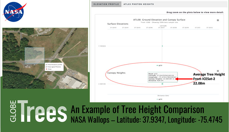
As part of the last five years of tree height observations associated with the GLOBE Observer, Trees Around the GLOBE Student Research Campaign, and the ICESat-2 mission, there has been a campaign-guided focus on how to compare the ground-based GLOBE tree height data with the tree height data measured, from space, by ICESat-2. It is possible to compare tree heights from GLOBE with the tree heights returned from ICESat-2 through an online tool called Open Altimetry (http://openaltimetry.org). Below is an example of one such comparison. You can read and view more about how to do a tree height comparison on our Trees Around the GLOBE Student Research Campaign Online Tools and Tutorials Page.
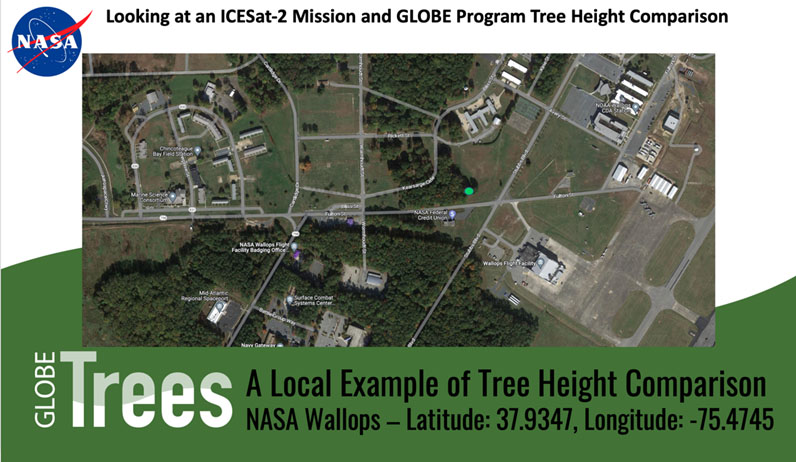
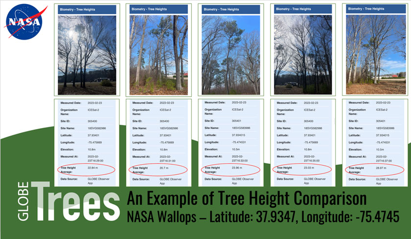
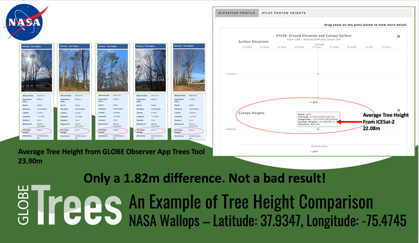
In the comparison below, ICESat-2 dropped a photon on the top of five trees at a specific location at the NASA Wallops Flight Facility in Wallops Island, Virginia, USA. Please note that when the ICESat-2 photon travels from the ICESat-2 satellite to the ground, a distance of 299 miles (481 kilometers), the photon spreads out to approximately 13 meters in diameter. What that means is that the tree height measured by ICESat-2 is the average tree height of all the trees within that 13 meter diameter footprint. In this example below, that would be five trees.


Through the combination of the ground-based tree height observations from The GLOBE Program and GLOBE Observer, the space-based observations from the NASA ICESat-2 mission, and the analysis of data from students and educators as part of the Trees Around the GLOBE Student Research Campaign, five years of tree observations have yielded a wealth of vital information to GLOBE participants and researchers at NASA and beyond.
You can learn more at the following websites:
Trees Around the GLOBE Student Research Campaign
Open Altimetry for ICESat-2 Data
About the Author
Brian Campbell (NASA Wallops/GST, Inc.) is a NASA Senior Earth Science Specialist and Subject Matter Expert at the NASA Goddard Space Flight Center’s Wallops Flight Facility in Wallops Island, Virginia, USA. Brian is also the Trees Around the GLOBE Student Research Campaign Lead and the Trees Science Lead for The GLOBE Program’s GLOBE Observer citizen science program. Brian, in his 23rd year at NASA, works with local to international students, educators, citizen scientists, and researchers in over 100 countries.
Comments
View more GLOBE Observer news here.


