News - GLOBE Observer
New resources to support research

GLOBE has been hard at work behind the scenes creating new tools and resources to make it even easier to use GLOBE data in your research. Keep reading to learn more about the new resources GLOBE has launched in the last year to make it easier to do your science.
New resources to support research:
- Analysis-ready datasets
- Photos
- API
- User guide
- Publications
- Video walk-throughs
- App status
- Mailing list
- Report a problem
Analysis-ready datasets
GLOBE data is publicly available. You can always access raw GLOBE data. Now curated subsets of data that have gone through additional post-processing are also available. These analysis-ready datasets include:
Have an analysis-ready dataset you’d like to contribute? Contact us.
Photos

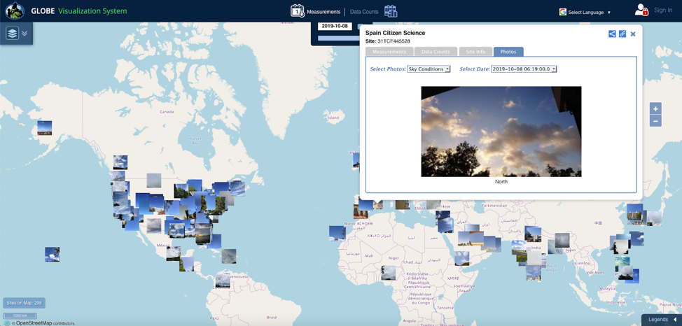
Photos provide a critical way to corroborate what a participant reports in an observation. Participants are given the option to include photos when they take an observation. In the era of smartphones, lots of participants now regularly submit multiple high-quality images alongside their observations. All of those photos are now included when you download GLOBE data. GLOBE stores each photo at a unique URL on the GLOBE servers. What you get in the downloaded dataset are the photo URLs. Clicking on a URL opens the original image in an internet browser window.
As participants submit their observations, the data pops up on GLOBE’s map. Check out the latest photos and observations with these quicklinks:
API
API stands for Application Programming Interface. The new API is much faster than GLOBE’s longstanding online data portal called the Advanced Data Access Tool (ADAT) and unlocks several new capabilities.
The new API supports:
- JSON and GeoSON output formats
- Command line queries
- Automated data retrieval
- More flexible, customizable queries
- Large data queries (note: there is a 1,000,000 observation limit per query)
Watch this 3-min tutorial on how to use the API.
User guide
The GLOBE Data User Guide v1 provides technical documentation describing how GLOBE data are collected, algorithms and derivations, quality assurance procedures, and data variables, units, and definitions. The User Guide is planned to be updated approximately once a year, with updated versions released around the GLOBE Annual Meeting in July. Between versions, updates are posted online.
In addition to the User Guide, the technical document NASA GLOBE Clouds: Documentation on How Satellite Data is Collocated to Ground Cloud Observations was also recently released online. This document describes in detail how the team at NASA Langley Research Center performs satellite matching with GLOBE Clouds observations.
Publications
Wondering how other scientists are using GLOBE data in their research? A list of peer-reviewed publications and conference presentations is now maintained on the GLOBE Observer website.
Spotlight:
Dodson et al., 2019, Eclipse Across America: Citizen
Science Observations of the 21 August 2017 Total Solar Eclipse,
Journal of Applied Meteorology & Climatology, https://doi.org/10.1175/JAMC-D-18-0297.1
Video walk-throughs
GLOBE has released a library of new videos that walk users through how to use the app and how to access the data.
- GLOBE Data Fundamentals - the basics about GLOBE data and how to access it
- GLOBE Observer Trees - introducing a new feature in the app that lets you measure tree height with just a smartphone
- Getting Comfortable with ICESat-2 Height Data and the Open Altimetry Online Tool - the basics of how to compare GLOBE student and citizen science tree height data to height data from the NASA Ice, Cloud, and land Elevation Satellite-2 (ICESat-2).
- GLOBE Observer Land Cover: Getting Started - how to make a land cover observation with your phone
- GLOBE Observer Clouds: Getting Started - how to make a cloud observation with your phone
- GLOBE Observer Mosquito Habitat Mapper: Getting Started - how to use your phone to report mosquito breeding ground. Later follow-on videos scheduled for release in 2020 will demonstrate how to identify the types of mosquitoes larvae at each site.
- How to Map, Analyze, and Communicate with GLOBE.gov Citizen Science Data - how to map, analyze, and create story maps with GLOBE data in ArcGIS Online. Credit: Joseph Kerski (ESRI).
App status
This is a new page on the GLOBE Observer site that briefly lists changes, updates, and currently known issues related to the GLOBE Observer app and data.
Mailing list
Subscribe for updates about GLOBE data, trainings, meetings, and publications.
Report a problem
This isn’t a new capability, but we want to remind our data end users that they are encouraged to report errors or inconsistencies they discover in GLOBE data. Please report issues to help@globe.gov and include the following information in your email:
- Your name
- Your organization
- Your contact information
- Brief description of how you are using GLOBE data
- Date (approximate) issue was discovered
- Description of the issue
Comments
View more GLOBE Observer news here.


