


NASA Response Mappers - GLOBE Observer
Open social media sharing options menu


NASA Response Mappers
Project Description:
The NASA Disasters Response Coordination System provides a variety of data products to emergency managers to help in disaster response efforts and decision making. They established this pilot project to determine the utility of GLOBE Land Cover observations in disaster response and recovery. To accomplish this, NASA Disasters are requesting regular observations during the peak hurricane season when hurricane awareness is higher. They ask that NO observations be made during a hurricane or in dangerous conditions, rather periodic observations from August through October. Documentation of no change is also helpful. For the GLOBE data to be impactful, regular (weekly or monthly) observations of a particular location are needed over a wide geographic area.
For more details, read the article from the NASA Disasters Program, "Become a NASA Response Mapper: Help Strengthen Hurricane Response from the Ground Up."
For more details, read the article from the NASA Disasters Program, "Become a NASA Response Mapper: Help Strengthen Hurricane Response from the Ground Up."
Project Impact:
GLOBE observations provide localized, timely, and geolocated photos which may help emergency managers. These photos can fill gaps in time and space that exist in satellite data and traditional information from official field reporting. First responders may use the observations to understand the extent of area impacted or support damage assessments of homes, businesses, roads, utilities, etc. Observations could help recovery personnel understand the extent of debris, or government agencies gain insight into cropland damage or document high water marks. GLOBE photos can also help verify satellite data.
Protocols Used:
Active Dates:
01 August to 31 October 2025
Special User Instructions and Tags:
Using the Land Cover protocol, please make observations of the same location either weekly (ideal) or monthly to document any change (or lack of change) to the area. While the pilot follows a periodic schedule, in the event of hazardous conditions, no photos will be requested to ensure user safety. Land cover photos can be uploaded via the GLOBE Observer app. You may note context or specific details you’d like to flag in the field notes section. For example, tags such as: flood, dry, damage, nochange
Please join the NASA Response Mappers team to help identify data collected for this project.
SAFETY NOTE: There is innate risk during hurricane season, but you should NEVER put yourself in danger to collect observations. Do not collect data during or immediately following severe storms. Experiencing a natural disaster can be traumatic, and we encourage you to consider your mental health before collecting observations.
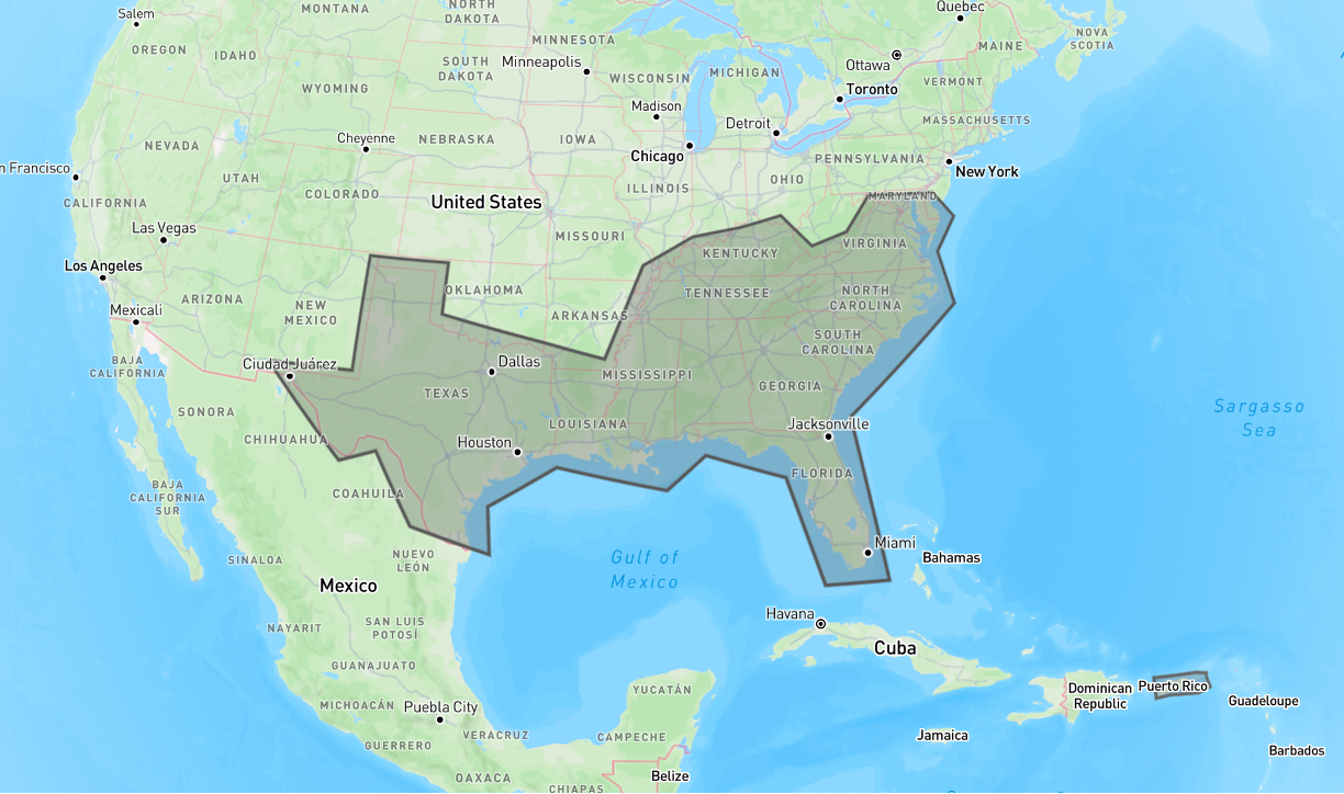
Region(s) of Interest:
Data collection is requested in areas in the south and southeast of the United States, including the states of Texas, Louisiana, Mississippi, Alabama, Tennessee, Kentucky, Georgia, Florida, North Carolina, South Carolina and Virginia, as well as Puerto Rico and the U.S. Virgin Islands.
Introductory Webinar
Mid-Season Call for Data Webinar
Educational Resources
If you are participating in NASA Response Mappers as an educator, librarian, or organization, you can find related educational resources and Literacy Connections under GLOBE Educator Resources to Engage with NASA Projects.
For More Information:
Read the article from the NASA Disasters Program, "Become a NASA Response Mapper: Help Strengthen Hurricane Response from the Ground Up."
Please contact project lead Kristen Okorn at the NASA Disasters Response Coordination System with any questions.
Please contact project lead Kristen Okorn at the NASA Disasters Response Coordination System with any questions.
Short link to this page: https://observer.globe.gov/nasa-response-mappers