Trees Science - GLOBE Observer
Trees Science
Jump to: Why study trees? -- Why does NASA want this information? -- Studying Forests with Lasers (Video) -- Quick Facts About Trees -- Publications related to GLOBE Trees data
Why study trees?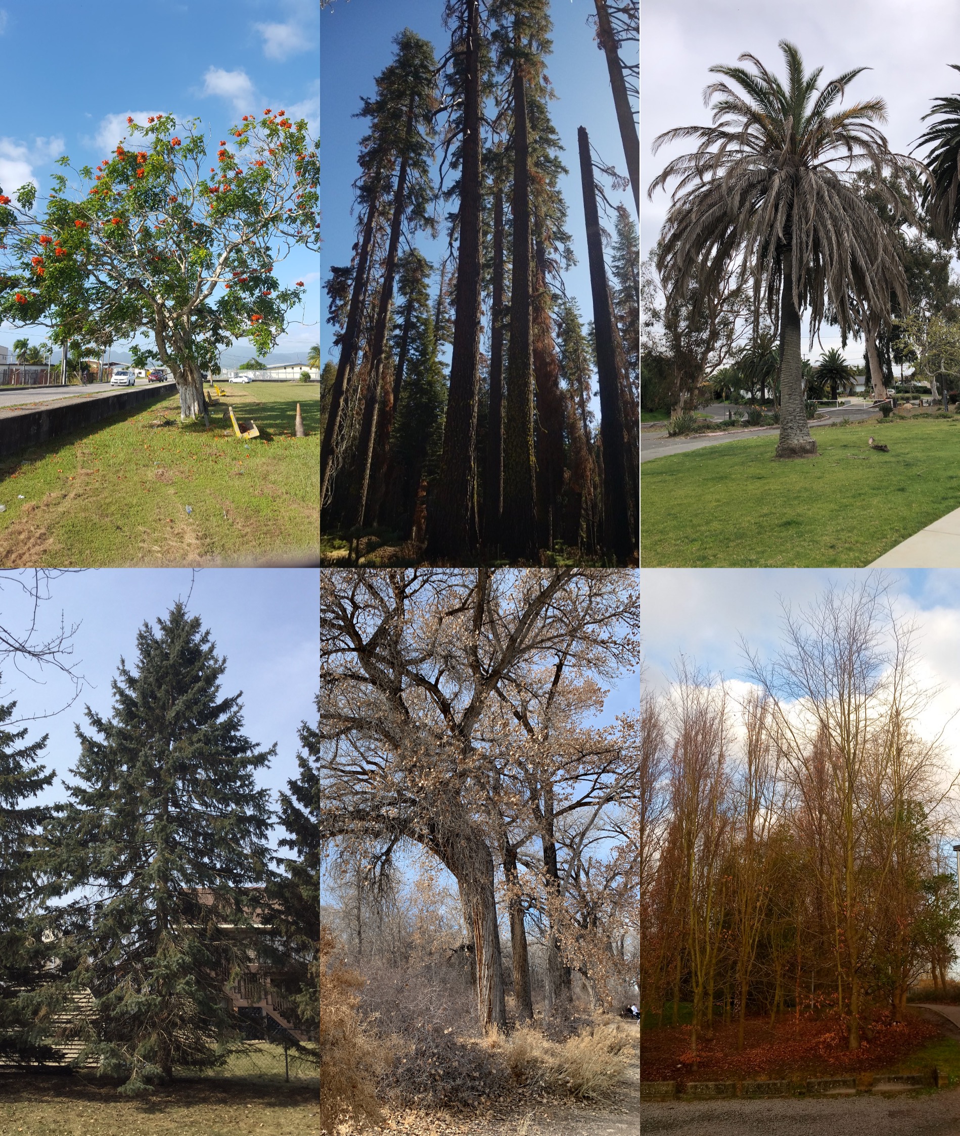
Biometry is the measuring of living things, such as the height of trees or shrubs, and can add valuable information to land cover data needed for planning or research. For example, tree height is the most widely used indicator of an ecosystem's ability to grow trees, so tracking tree height over time can help us to assess the ecological health of a given area. Tree circumference can be used by foresters and managers to calculate the approximate age of the tree, and the measurements are also used to estimate the amount of standing timber in a forest. Both tree height and trunk circumference can also help to measure biomass, the total mass of living material above ground measured across a particular area.
While knowing an ecosystem’s biomass is useful for many applications such as farming, logging, and wildlife management, another helpful unit of measure in an ecosystem is how much carbon is stored in the plants. Understanding how terrestrial ecosystems store and transfer carbon to and from the atmosphere is essential to understanding climate change, so biomass estimates are often converted to net carbon storage. Terrestrial ecosystems contain carbon in the form of plants, animals, soils and microorganisms (bacteria and fungi). Of these, plants and soils are by far the largest reservoirs of stored carbon. Of the various kinds of tissues produced by plants, woody stems such as those produced by trees have the greatest ability to store large amounts of carbon through continued growth, because wood is dense and trees can be large. Collectively, the Earth’s plants store approximately 560 petagrams of carbon, with the wood in trees being the largest fraction.
More about:
Carbon dioxide is a greenhouse gas contributing to climate change. Plants play an important role in the climate system by sequestering, or “fixing” carbon that they take in during the process of photosynthesis and turning it into plant biomass. Understanding the amount of carbon stored in vegetation is important for communities making land management decisions related to climate change mitigation.
Pools, also known as stocks or reservoirs, represent any place where a given substance can reside. In the carbon cycle, examples of individual pools might include soils, leaves, wood, whole trees and their supporting ecosystems, or the entire biosphere. Note that these examples overlap and that carbon pools can be grouped together or treated separately. Carbon in trees can be considered a single carbon pool, or it can be divided into leaves, wood and roots. If necessary for ecosystem monitoring, these pools can be further subdivided into sugars, starches, and other compounds. Alternatively, trees can be grouped with crops, grasses and shrubs to form a single global plant pool. How scientists make these decisions depends on the questions being asked and the scale of a particular study.
The movement of material from one pool to another is known as a flow, or flux, similar to the flow of water through the hydrologic cycle ![]() . For example, in the global carbon cycle, carbon moves from the atmosphere to the plant pool through the process of photosynthesis
. For example, in the global carbon cycle, carbon moves from the atmosphere to the plant pool through the process of photosynthesis ![]() (which also makes oxygen). Photosynthesis represents a flux and is, in fact, one of the most important fluxes in the carbon cycle. The flux of carbon out of this plant pool occurs through the transfer of leaves and other dead plant materials to soils (a process known as litterfall) and through respiration, which releases carbon dioxide back into the atmosphere. These examples are just a few of the pools and fluxes that make up the entire global carbon cycle.
(which also makes oxygen). Photosynthesis represents a flux and is, in fact, one of the most important fluxes in the carbon cycle. The flux of carbon out of this plant pool occurs through the transfer of leaves and other dead plant materials to soils (a process known as litterfall) and through respiration, which releases carbon dioxide back into the atmosphere. These examples are just a few of the pools and fluxes that make up the entire global carbon cycle.
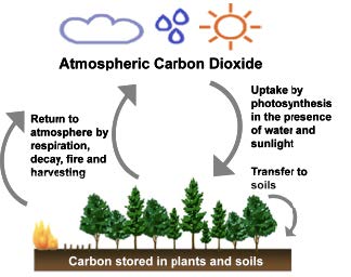
Image from GLOBE's Introduction to the Global Carbon Cycle
Trees regulate climate at local, regional and continental scales, by producing atmospheric moisture and rainfall, and controlling temperature. Tree ranges are already changing as a result of changes in climate. Scientists and forest managers are concerned about the effect that changes temperature and precipitation will have on forests and their species composition. Trees respond to stress by producing more seeds. These seeds are dispersed by water, wind, and animals. Those that are transported to a suitable environment for germination will grow. As climate warms and precipitation regimes change regionally, the most suitable sites for germination may be different than they are today, and that may mean that higher elevations and cooler latitudes will provide better conditions for seedlings than the present location of their parent tree. This is one way that a species’ range can migrate. Humans also transport plants and seeds to new ranges, intentionally or inadvertently, and changes in climate may help those transplants thrive in the new areas as invasive species ![]() . The first indications of a changing tree range can be ascertained by counting and monitoring the size of trees found in a given area and comparing these data with nearby regions.
. The first indications of a changing tree range can be ascertained by counting and monitoring the size of trees found in a given area and comparing these data with nearby regions.
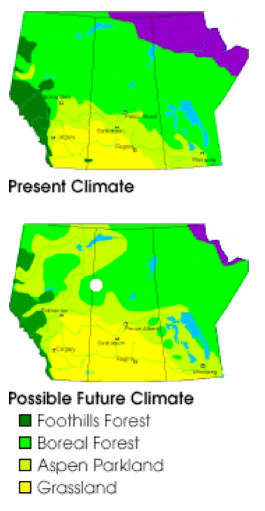
Projected changes in the Northern Hemisphere's boreal forest resulting from climate change, story in NASA's Earth Observatory ![]() . (Images courtesy Ted Hogg, Northern Forestry Division of the Canadian Forest Service.)
. (Images courtesy Ted Hogg, Northern Forestry Division of the Canadian Forest Service.)
Why does NASA want this information?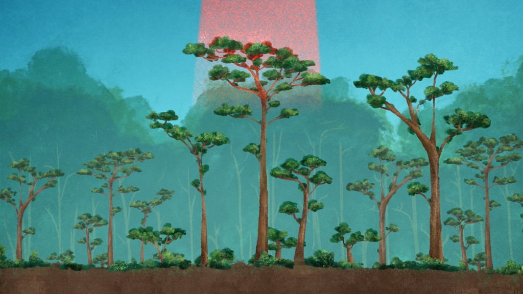
One of the focus areas of NASA’s Earth science research program ![]() is looking at questions related to the carbon cycle
is looking at questions related to the carbon cycle ![]() , especially how forests, other vegetation and the ocean are absorbing carbon emissions. Forests are one of the major carbon sinks, which are areas that absorb large amounts of carbon dioxide from the atmosphere, storing it for decades in trunks and roots. Satellite observations have illustrated how green plants have expanded their territory in North America, as warmer temperatures allow them to grow farther north. Height-measuring instruments, like radars and lidars on aircraft or satellites, add a third dimension to the land cover information, allowing researchers to estimate how much material — and therefore how much carbon — is stored in a forest.
, especially how forests, other vegetation and the ocean are absorbing carbon emissions. Forests are one of the major carbon sinks, which are areas that absorb large amounts of carbon dioxide from the atmosphere, storing it for decades in trunks and roots. Satellite observations have illustrated how green plants have expanded their territory in North America, as warmer temperatures allow them to grow farther north. Height-measuring instruments, like radars and lidars on aircraft or satellites, add a third dimension to the land cover information, allowing researchers to estimate how much material — and therefore how much carbon — is stored in a forest.
NASA uses field campaigns and sensors on satellites and the International Space Station (ISS) to improve our understanding of how much carbon is being stored in terrestrial ecosystems and how this could change as patterns of drought, fire, and forest ecosystems shift in a changing climate. For example, NASA has launched satellites such as the Ice, Cloud and land Elevation Satellite-2 (ICESat-2) ![]() as well as instruments on the International Space Station such as the Global Ecosystem Dynamics Investigation (GEDI)
as well as instruments on the International Space Station such as the Global Ecosystem Dynamics Investigation (GEDI) ![]() , which use lasers to measure the height of Earth’s surface below them as they orbit our planet. Measuring this third dimension of forest structure and improve estimates of how much carbon is stored above ground in large forests.
, which use lasers to measure the height of Earth’s surface below them as they orbit our planet. Measuring this third dimension of forest structure and improve estimates of how much carbon is stored above ground in large forests.
Ground sources of data are also needed to verify the measurements from satellites, and observations from citizen scientists can help fill in gaps in that data. For example, tree height measurements will help scientists working on NASA missions like ICESat-2, which is measuring the heights of forest canopies worldwide. Those satellite observations can be complemented by citizen scientists using the GLOBE Observer app, who will be able to gather tree heights from many more places than the ICESat-2 scientists alone could measure. ICESat-2 scientists plan to look for places where clusters of citizen scientist measurements overlap with ICESat-2’s measurements, and compare the two datasets.
More about:
Field measurements of trees can be time consuming and expensive, and some forests are quite remote and difficult to access. Some sampling methods rely on cutting down the trees, which can result in an underestimate of carbon content compared to other methods that use lidar ![]() or other remote sensing data. The combination of ground observation strategies and satellites allows the research and conservation community to observe forest change in a more cost-effective way.
or other remote sensing data. The combination of ground observation strategies and satellites allows the research and conservation community to observe forest change in a more cost-effective way.
Lidar is similar to the radar commonly used to track everything from airplanes in flight to thunderstorms. But instead of bouncing radio waves off its target, lidar uses short pulses of laser light, part of the visible portion ![]() of the electromagnetic spectrum
of the electromagnetic spectrum ![]() . Some of that light reflects off of tiny particles in the atmosphere, or off the Earth’s surface, and back to a telescope or instrument aligned with the laser. By precisely timing when the light left the sensor and the return of the lidar "echo," and by measuring the laser light received by the telescope, scientists can accurately determine the location, distribution and nature of the vegetation below the sensor, as well as the height of the Earth's surface.
. Some of that light reflects off of tiny particles in the atmosphere, or off the Earth’s surface, and back to a telescope or instrument aligned with the laser. By precisely timing when the light left the sensor and the return of the lidar "echo," and by measuring the laser light received by the telescope, scientists can accurately determine the location, distribution and nature of the vegetation below the sensor, as well as the height of the Earth's surface.
During the last two decades, high-resolution visible/near infrared remote sensing data have been used to successfully characterize relevant aspects of forested habitats over broad areas, but have typically been unable to describe three-dimensional (3-D) structural characteristics. Lidar data can provide critical new information on tree canopy structure and overall vegetation characteristics to better assess forest habitats. Improved habitat quality maps that capture the vertically and horizontally complex forest systems would enable more rapid and continuous assessment of changes in these ecosystems. Satellite remote sensing that provides information about this complexity will be extremely valuable to better understand plant species diversity and population change over time.
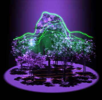
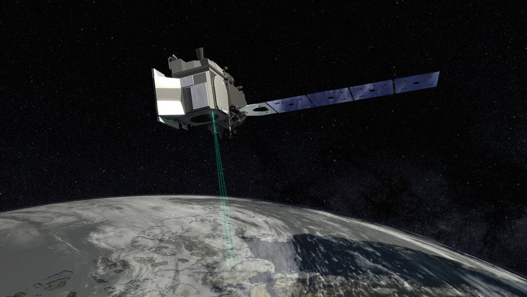
Image source: NASA's ICESat-2 mission ![]()
Launched in September 2018, NASA’s Ice, Cloud and land Elevation Satellite-2 (ICESat-2) ![]() mission uses one of the most spatially dense and high precision active remote sensing instruments for global measurement of surface elevation. The micro-pulse, multi-beam Advanced Topographic Laser Altimeter System (ATLAS) instrument, firing 10,000 laser pulses per second, provides global terrain elevation, global canopy heights, and global canopy cover. Coupled with other data sources (e.g., Landsat
mission uses one of the most spatially dense and high precision active remote sensing instruments for global measurement of surface elevation. The micro-pulse, multi-beam Advanced Topographic Laser Altimeter System (ATLAS) instrument, firing 10,000 laser pulses per second, provides global terrain elevation, global canopy heights, and global canopy cover. Coupled with other data sources (e.g., Landsat ![]() ), ICESat-2 could allow for the consistent representation of canopy structure across the entire United States as well as other continents.
), ICESat-2 could allow for the consistent representation of canopy structure across the entire United States as well as other continents.
Image source: NASA's ICESat-2 mission ![]()
NASA’s Global Ecosystem Dynamics Investigation (GEDI) ![]() mission launched in December 2018. Situated aboard the International Space Station, GEDI's lasers create detailed 3D maps of Earth’s forests and topography – providing innovative and unique spaceborne observations that complement ICESat-2 data. The GEDI ecosystem lidar is specifically designed to provide scientists with additional detailed information about forest structure: How tall the forest is, how dense its branches are, and the vertical and horizontal distribution of its foliage. All of this information yields crucial insights into Earth’s global carbon cycle by fostering a better understanding of how forests store carbon and what happens to that carbon when trees are cut down or disturbed. Forests support numerous plant and animal species and influence hydrologic systems around the globe. Understanding their structure can help biologists better understand Earth’s forest habitats and biodiversity.
mission launched in December 2018. Situated aboard the International Space Station, GEDI's lasers create detailed 3D maps of Earth’s forests and topography – providing innovative and unique spaceborne observations that complement ICESat-2 data. The GEDI ecosystem lidar is specifically designed to provide scientists with additional detailed information about forest structure: How tall the forest is, how dense its branches are, and the vertical and horizontal distribution of its foliage. All of this information yields crucial insights into Earth’s global carbon cycle by fostering a better understanding of how forests store carbon and what happens to that carbon when trees are cut down or disturbed. Forests support numerous plant and animal species and influence hydrologic systems around the globe. Understanding their structure can help biologists better understand Earth’s forest habitats and biodiversity.
Above: Profile measurements from GEDI data of a South Carolina woodland in the winter of 2019. Darker greens show where the leaves and branches were denser, while lighter areas show sparser parts of the canopy. Read more from NASA's Earth Observatory ![]() .
.
The science leads for the Trees tool, Brian Campbell, gives updates about recent research being done using the data collected via the GLOBE Observer app. (Originally aired during the GLOBE Observer Connection-Conversation-Celebration event held 26 July 2022.)
Studying Forests with Lasers - Video
One example of how scientists study forests and tree height from above was an airborne mission with flights conducted from 2013-2016. Flying over the Brazilian Amazon with an instrument firing 300,000 laser pulses per second, NASA scientists have made the first 3D measurements of forest canopies in the region. With this research they hope to shed light on the effects of prolonged drought on forest ecosystems and to provide a potential preview of stresses on rainforests in a warming world. Read the full NASA feature story ![]() .
.
Quick Facts About Trees
Tracking how trees are changing over time can help us estimate the number and health of trees that are growing across an area. Tree height is the most widely used indicator of an ecosystem’s ability to grow additional trees if land cover is disturbed. Observing tree height allows NASA scientists to understand the gain or loss of biomass which can inform calculations of the carbon that trees and forests either take in from or release into the atmosphere. Tree circumference measurements can be used to estimate the volume, biomass, and carbon storage of trees.
Trees cool and moisten our air and fill it with oxygen (as part of the process of photosynthesis) and can help balance our carbon budget. Forests are considered one of the world’s largest pools for all of the carbon emitted into the atmosphere through natural processes and human activities. They cover about 30 percent of Earth’s land surface, while accounting for 50 percent of overall plant productivity. As much as 45 percent of the carbon stored on land is tied up in forests. Trees undergo photosynthesis. Photosynthesis is a complicated process where carbon dioxide and water are converted to glucose (a simple sugar) and oxygen.
NASA's Ice, Cloud, and land Elevation Satellite-2 (ICESat-2) was launched in September 2018 and uses lasers to measure the height of Earth’s surface beneath it from 88°S to 88°N latitude. In addition to measuring ice sheets, sea ice, and glaciers, it also surveys the heights of the world’s lands, forests, lakes, urban areas, cloud cover and more, adding a third dimensional view of Earth from space.
ICESat-2 elevation data (and ICESat data from 2003 to 2009) can be visualized on the OpenAltimetry tool, the product of a collaboration between the National Snow and Ice Data Center, the Scripps Institution of Oceanography, and the San Diego Super Computer Center at UC San Diego. Data for the ICESat-2 mission were released to the public on May 28, 2019. OpenAltimetry provides access to all ICESat-2 data for which there is a complete set of data products, including canopy (tree) height. If the ICESat-2 satellite collected data over your observed tree location, you can quickly view ICESat-2 elevation data corresponding to your tree’s latitude and longitude. This ICESat-2 dataset will continue to expand as ICESat-2 collects new data in the years to come.
The Global Ecosystem Dynamics Investigation (GEDI) measures precise height measurements of surface water, ice, vegetation, and the land surface. The data can improve estimates of flood risk from storms, fresh water and forest resources, and can help identify priorities for biodiversity conservation. It covers the same region of Earth that the International Space Station passes over, which encompasses most of the regions with extensive vegetation and human population.
GLOBE tree height data can serve as a source of data comparison for the ICESat-2 satellite. ICESat-2 utilizes an onboard laser altimeter system to measure the height of our planet, one green photon at a time. The technology of ICESat-2 can measure the height of trees all around our planet. By making observations, GLOBE Observers can share their data with NASA scientists and can be part of vital missions that make NASA science even better.
Tracking how trees are changing over time can help estimate the amount of trees that make up an area’s biomass – the total mass of organisms in a given area or volume. Taking these observations can serve as a step to help scientists and researchers understand how trees help balance Earth’s carbon budget as our climate evolves.
Publications Related to GLOBE Trees
For a more complete list of GLOBE Observer publications and presentations, visit the publications page.
Enterkine, J., Campbell, B.A., Kohl, H., Glenn, N.F., Weaver, K., Overoye, D., and Danke, D. (2022). The potential of citizen science data to complement satellite and airborne lidar tree height measurements: lessons from The GLOBE Program. Environmental Research Letters, 17 (7). https://doi.org/10.1088/1748-9326/ac77a2
Technical Report: GLOBE Observer Data: 2016–2019
Amos, H. M., Starke, M. J., Rogerson, T. M., Colón Robles, M., Andersen, T., Boger, R., et al., (2020). GLOBE Observer Data: 2016–2019. Earth and Space Science, 7, e2020EA001175. https://doi.org/10.1029/2020EA001175


